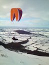
Below are four bits of tracklog from Sunday’s fish and chip run.
If you were about to cross Runswick Bay which line would you choose and why?
For those unfamiliar with this area we are travelling from top left to bottom right.
what's my line - Something to have a think about safety wise
Moderator: Club Moderators
-
chrisfozz
- Regular
- Posts: 961
- Joined: Wed Dec 28, 2005 7:14 pm
- Full Name: chris foster
- Location: Northumberland
- Contact:
what's my line - Something to have a think about safety wise
- Attachments
-
- F&C.jpg (720.34 KiB) Viewed 17404 times
-
colin keightley
- BHPA Club Coach

- Posts: 2483
- Joined: Fri Oct 12, 2007 5:22 pm
- Full Name: Colin Keightley
- Location: Stockton
- Contact:
-
Graeme Gilroy
- Regular
- Posts: 518
- Joined: Sun Apr 19, 2009 8:55 pm
- Full Name: Graeme Gilroy
- Location: newcastle formerly of Murton
Track 2
Looks like whoever track 2 is they spent a bit of time topping up their height before making a run for it out the front of Runswick village, so would agree with Colin, I'm nee export like .
Graeme
Graeme
it's a fine line between heaven and here
Aren't 1 & 4 almost identical?
Both these tracks moreorless hug the coast line and don't cross over water?
I don't know this area and cant judge height flown - but looking at wind direction is their any risk of rotor when flying just inland behind the coast?
Both these tracks moreorless hug the coast line and don't cross over water?
I don't know this area and cant judge height flown - but looking at wind direction is their any risk of rotor when flying just inland behind the coast?
07879215524
Livetrack Graeme52
Flying for Fun Only.
Livetrack Graeme52
Flying for Fun Only.
-
gary stenhouse
- Superstar
- Posts: 6288
- Joined: Tue Dec 20, 2005 7:21 pm
- Full Name: Gary Stenhouse
- Location: Company Director
-
colin keightley
- BHPA Club Coach
- Posts: 2483
- Joined: Fri Oct 12, 2007 5:22 pm
- Full Name: Colin Keightley
- Location: Stockton
- Contact:

You also have to take into consideration that the image is taken at high tide and the crossings were made at low tide.
I know which is mine, so don't really thing I can comment to much, except to say I wasn't really topping up height, I was tarting about looking at my map, the route out of Brunswick bay at the south end and the wind direction, trying to work out if indeed it would be possible before making the move south whilst also weighing up the options of returning to Staithes and then to Marske.
So as well as the routes, there's a lot going on in the mind of the pilots,,,,or should be.
I am a cautious pilot on the coast and well aware that the coastline minders around and can catch out the unwary and will avoid possible areas of rotor and sink by the biggest margin possible.
See you out there!!!!!
Surf crazed and dazed
Livetrack24 Nezzy01
Surf crazed and dazed
Livetrack24 Nezzy01
-
ron freeman
- Seasoned
- Posts: 3147
- Joined: Wed Dec 21, 2005 10:50 pm
- Full Name: Ron Freeman CFI
- Location: Cheviot hills, Northumberland
- Contact:
No doubt
Without doubt the no 2 is the best track, stopping to top up height to the max and then take the best line as to avoid rotor (if any)
Iv'e studied this run for a long time now and I feel the safest way to attempt it would be to wait for a forecast where the wind in the morning was n.n.east then going round to a n.east after dinner to give you maximum safety.
The pictures look like low tide due to the water marks on the sand.
Iv'e studied this run for a long time now and I feel the safest way to attempt it would be to wait for a forecast where the wind in the morning was n.n.east then going round to a n.east after dinner to give you maximum safety.
The pictures look like low tide due to the water marks on the sand.
Maximise your time & dosh do both Hanggliding & Paragliding ")
-
Luis Martinez Iturbe
- Chatty
- Posts: 157
- Joined: Wed Jun 03, 2015 11:53 pm
- Location: Seaham
Very interesting post, I like to analyze my own flights and compare them with others, it's a good way of learning I believe... but keep in mind is not 100% accurate, there is a slight gap with google maps in certain areas.
If you analyze my flight for instance you see in the map that I landed in some tree in Robin Hood's Bay, I remeber getting my wing dirty with sand
http://www.nhpc.org.uk/nhpc/modules.php ... ghtID=8171
If you analyze my flight for instance you see in the map that I landed in some tree in Robin Hood's Bay, I remeber getting my wing dirty with sand
http://www.nhpc.org.uk/nhpc/modules.php ... ghtID=8171
If you need a windummy, please give me a ring!!
0751 495 6932
Livetrack24: lmiturbe
0751 495 6932
Livetrack24: lmiturbe
-
Luis Martinez Iturbe
- Chatty
- Posts: 157
- Joined: Wed Jun 03, 2015 11:53 pm
- Location: Seaham
-
gary stenhouse
- Superstar
- Posts: 6288
- Joined: Tue Dec 20, 2005 7:21 pm
- Full Name: Gary Stenhouse
- Location: Company Director
for me that day I was a good height most of the time and often double the height of the cliffs and never put a turn in accept for half turn at Whitby and one near robin hoods bay as I was going to turn back.
however I can confirm Whitby southside was definitely out of wind as it was coming from round the corner slightly. luckily I quickly realised by my ground speed but could feel turbulence more than anywhere else on the flight. I think for those not carrying detailed map gps then it was easy to make a mistake going into robin hoods bay.
would be good to get the tracklogs emailed to me so I can play them in seeyou at a meeting some time.
-
colin keightley
- BHPA Club Coach
- Posts: 2483
- Joined: Fri Oct 12, 2007 5:22 pm
- Full Name: Colin Keightley
- Location: Stockton
- Contact:
-
Sad Northerner

- Regular
- Posts: 767
- Joined: Tue Dec 20, 2005 8:01 pm
- Location: Uganda
An excellent post/question Chris. My take on this is;
It hard to see exactly what the situation is in these cases as it is hard to get a true perspective on things but in my eyes pilot no 2 wins the day;
1. he appears top up when he has the opportunity, Why not?, every ft of height only serves to reduce and risk of being rotor and extend your glide distance.
2. he makes his glide leaving a good margin between himself and the potential ground associated rotor. I really can't see the point of hugging a ridge that is out of lift your only extending the distance you have to fly to get to the next lifting ridge.
3. but perhaps mostly he deserves credit because he appears to consider (have a strategy for) the next move; flying xc on the coast is not just ridge soaring it is a series of transitions each of which need a plan.
Ali
He who feared he would not succeed sat still.
Do everything in moderation; except moderation which you should do to the MAX!!!
Do everything in moderation; except moderation which you should do to the MAX!!!

Richards vario is still refusing to start and I'm reluctant to attach it to my computer.
The next move getting out of Runswick Bay was actually more of an issue. I witnessed one pilot, not from our club, land on the leeward side of the point on the shingle beach, I had heard Gary on the radio earlier in the day questioning the route and had seen another pilot very low in a rotor area just make it via the front route.
I tested both routes a couple of times topping up height before each attempt, eventually coming to the conclusion that I couldn't make the front route safely so opted for the very uncomfortable higher back route.
For me, on that day, this was a step to far that fortunately I got away with, as it happens, quite easily.
In my opinion only one pilot to my knowledge made the right decision at this point, Nick on a Nova from North Yorks,,,,,he landed and walked away safely!
What did the rest of us gain,,,,a few km more!! Is it worth it?
See you out there!!!!!
Surf crazed and dazed
Livetrack24 Nezzy01
Surf crazed and dazed
Livetrack24 Nezzy01

-
chrisfozz
- Regular
- Posts: 961
- Joined: Wed Dec 28, 2005 7:14 pm
- Full Name: chris foster
- Location: Northumberland
- Contact:
Runswick Bay
I’ve had another look at the tracklogs and in my view there is a discrepancy of somewhere between 20 to 70m with the track shown to the south west of where it should be, as pointed out by Gary and Luis. I think if the tracks were displayed accurately then it would show all pilots avoiding areas of potential rotor. So it would seem my original question was a bit pointless, although it is good to see people are able to identify where the rota is likely to be.
Having said that, I think my line would most closely resemble number 3. Why? - Particularly when I’m about to commit to a transition, like crossing Runswick Bay, I’ll take the time to do a few beats somewhere which is more or less into wind. I fly a reciprocal path and look at groundspeed on my gps to check out my assessment of wind direction and strength, usually it’s more or less how I imagined but sometimes I’m a little bit out and sometimes I’m quite a bit out. This is either because the wind has changed or because my perception of the orientation of the ridge I’m flying was wrong. I’m also using this time to build a picture in my mind of how I will fly the next transition. Ali and Brian Day’s posts above expand on what I’m doing here.
With better performance gliders these costal flights are becoming more and more accessible and for me they are a great experience, crossing Runswick Bay is quite committing but it’s a real buzz looking down on the surfers as I fly to the next area of lift. I hope having a look at these tracklogs has been useful and that the pilots concerned don’t mind me sharing there them in this way.
-
steve-gill
- Chatty
- Posts: 160
- Joined: Sun Dec 25, 2005 10:55 pm
- Location: Durham
-
John Wallis
- Seasoned
- Posts: 4072
- Joined: Tue Dec 20, 2005 7:17 pm
- Location: Northumberland
Its a funny thing Chris, when I look at traces of other flights around Runswick Bay they dont seem to match up when I was there. However, I am a bit of a duffer at this.
Everyone who lives dies, yet not everyone who dies, has lived. We take these risks not to escape life, but to prevent life from escaping us ...
-
steve-gill
- Chatty
- Posts: 160
- Joined: Sun Dec 25, 2005 10:55 pm
- Location: Durham
-
John Wallis
- Seasoned
- Posts: 4072
- Joined: Tue Dec 20, 2005 7:17 pm
- Location: Northumberland
-
steve-gill
- Chatty
- Posts: 160
- Joined: Sun Dec 25, 2005 10:55 pm
- Location: Durham
-
Graeme Gilroy
- Regular
- Posts: 518
- Joined: Sun Apr 19, 2009 8:55 pm
- Full Name: Graeme Gilroy
- Location: newcastle formerly of Murton